


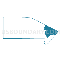
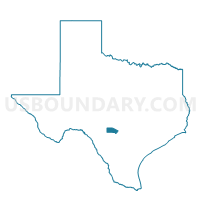
Voting District 0102, Bandera County, Texas
About
Outline

Summary
| Unique Area Identifier | 670216 |
| Name | Voting District 0102 |
| County | Bandera County |
| State | Texas |
| Area (square miles) | 72.90 |
| Land Area (square miles) | 72.72 |
| Water Area (square miles) | 0.18 |
| % of Land Area | 99.75 |
| % of Water Area | 0.25 |
| Latitude of the Internal Point | 29.72476790 |
| Longtitude of the Internal Point | -98.90364740 |
Maps

Graphs
Select a template below for downloading or customizing gragh for Voting District 0102, Bandera County, Texas


Neighbors
Neighoring Voting District (by Name) Neighboring Voting District on the Map
- Voting District 0009, Medina County, TX
- Voting District 0101, Bandera County, TX
- Voting District 0203, Bandera County, TX
- Voting District 0308, Kerr County, TX
- Voting District 0407, Bandera County, TX
- Voting District 11-1, Kendall County, TX
- Voting District 3128, Bexar County, TX
Top 10 Neighboring County Subdivision (by Population) Neighboring County Subdivision on the Map
- San Antonio Northwest CCD, Bexar County, TX (269,553)
- Boerne CCD, Kendall County, TX (27,018)
- Bandera CCD, Bandera County, TX (17,759)
- Castroville-LaCoste CCD, Medina County, TX (14,060)
- Center Point CCD, Kerr County, TX (4,260)
Top 10 Neighboring Place (by Population) Neighboring Place on the Map
Top 10 Neighboring Unified School District (by Population) Neighboring Unified School District on the Map
- Northside Independent School District, TX (516,430)
- Boerne Independent School District, TX (34,875)
- Bandera Independent School District, TX (17,313)
- Comfort Independent School District, TX (7,624)
Top 10 Neighboring State Legislative District Lower Chamber (by Population) Neighboring State Legislative District Lower Chamber on the Map
- State House District 122, TX (246,846)
- State House District 73, TX (187,204)
- State House District 80, TX (149,638)
- State House District 53, TX (145,845)
Top 10 Neighboring State Legislative District Upper Chamber (by Population) Neighboring State Legislative District Upper Chamber on the Map
- State Senate District 25, TX (984,664)
- State Senate District 24, TX (778,148)
- State Senate District 19, TX (766,044)
Top 10 Neighboring 111th Congressional District (by Population) Neighboring 111th Congressional District on the Map
Top 10 Neighboring Census Tract (by Population) Neighboring Census Tract on the Map
- Census Tract 1.02, Medina County, TX (7,709)
- Census Tract 3, Bandera County, TX (6,369)
- Census Tract 1.02, Bandera County, TX (4,913)
- Census Tract 1.01, Bandera County, TX (4,330)
- Census Tract 9608, Kerr County, TX (4,260)
- Census Tract 9703.02, Kendall County, TX (4,228)
- Census Tract 1821.03, Bexar County, TX (2,238)